…HOT AND DRY WIND WEDNESDAY AFTERNOON AND AGAIN THURSDAY AFTERNOON FOR MUCH OF CENTRAL AND EASTERN WASHINGTON…
…HOT AND DRY WIND WEDNESDAY AFTERNOON AND AGAIN THURSDAY AFTERNOON FOR MUCH OF CENTRAL AND EASTERN WASHINGTON…
…RED FLAG WARNING IN EFFECT FROM 1 PM WEDNESDAY TO 11 PM PDT THURSDAY FOR WIND AND LOW RELATIVE HUMIDITY FOR WASHINGTON COLUMBIA BASIN…PALOUSE…AND SPOKANE AREA…
The National Weather Service in Spokane has issued a Red Flag Warning for wind and low relative humidity, which is in effect from 1 PM Wednesday to 11 PM PDT Thursday. The Fire Weather Watch is no longer in effect.
Affected Area: Fire Weather Zone 673 East Washington Northern Columbia Basin (Zone 673) and Fire Weather Zone 674 East Washington Palouse and Spokane Area (Zone 674).
Winds: Southwest 10 to 15 mph with gusts to 25 mph. Localized gusts as high as 35 mph on the Waterville Plateau.
Relative Humidities: 7 to 14 percent Wednesday and in the valleys and 14 to 19 percent Thursday.
Impacts: Increased wind and low relative humidity will potentially increase fire spread potential of new or existing fires.
PRECAUTIONARY/PREPAREDNESS ACTIONS…
A Red Flag Warning means that critical fire weather conditions are either occurring now….or will shortly. A combination of strong winds…low relative humidity…and warm temperatures can contribute to extreme fire behavior.
…RED FLAG WARNING IN EFFECT FROM 1 PM WEDNESDAY TO 11 PM PDT THURSDAY FOR WIND AND LOW RELATIVE HUMIDITY FOR WASHINGTON COLUMBIA BASIN…PALOUSE…AND SPOKANE AREA…
The National Weather Service in Spokane has issued a Red Flag Warning for wind and low relative humidity, which is in effect from 1 PM Wednesday to 11 PM PDT Thursday. The Fire Weather Watch is no longer in effect.
* Affected Area: Fire Weather Zone 673 East Washington Northern Columbia Basin (Zone 673) and Fire Weather Zone 674 East Washington Palouse and Spokane Area (Zone 674).
* Winds: Southwest 10 to 15 mph with gusts to 25 mph. Localized gusts as high as 35 mph on the Waterville Plateau.
* Relative Humidities: 7 to 14 percent Wednesday and in the valleys and 14 to 19 percent Thursday.
* Impacts: Increased wind and low relative humidity will potentially increase fire spread potential of new or existing fires.
PRECAUTIONARY/PREPAREDNESS ACTIONS…
A Red Flag Warning means that critical fire weather conditions are either occurring now….or will shortly. A combination of strong winds…low relative humidity…and warm temperatures can contribute to extreme fire behavior.
Red Flag Warning for July 14, 15, 2021
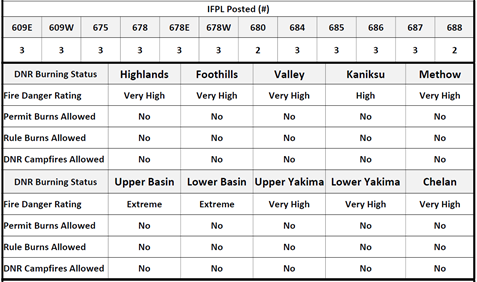
Fire Danger Ratings Rise Due In Parts of Eastern Washington
The Washington State Department of Natural Resources (DNR) and its partners are increasing Fire Danger Ratings and Industrial Fire Precaution Levels on DNR-protected lands in parts of eastern Washington.
Effective Friday, July 9:
- Fire danger will increase from Very High to Extreme in the Upper Basin Fire Danger Rating Area
- Industrial Fire Precaution Level (IFPL) will increase from Level 2 to Level 3 in zones: 678E, 678W, 685 and 687
Residents can find their Fire Danger Rating Area online here and can find more information about the IFPL System here.
Current IFPLs, Fire Danger Ratings and Burning restrictions
Red Flag Warning
…RED FLAG WARNING REMAINS IN EFFECT FROM 5 AM TO 8 PM PDT THUNDERSTORMS FOLLOWED BY WIND AND LOW RELATIVE HUMIDITY FOR NORTHERN WASHINGTON AND IDAHO…
- Affected Area: Fire Weather Zone 101 Northern and Central Idaho Panhandle (Zone 101), Fire Weather Zone 662 East Portion of North Cascades National Park/Lake Chelan National Recreational Area (Zone 662), Fire Weather Zone 684 East Washington Okanogan/Methow Valleys (Zone 684), Fire Weather Zone 685 East Washington North Cascades (Zone 685), Fire Weather Zone 686 East Washington Northeast (Zone 686) and Fire Weather Zone 687 East Washington Okanogan Highlands (Zone 687).
- Thunderstorms: Elevated early morning dry thunderstorms are expected. Showers and thunderstorms will continue through the afternoon along the Canadian border.
- Winds: West-Northwest 10 to 20 mph with gusts to between 25 and 35 mph from late morning into afternoon. From Okanogan Highlands to the Northern Panhandle, the strongest gusts will be across the southern portions of these fire weather zones.
- Relative Humidities: 15 to 25 percent in the valleys and 25 to 40 percent over the higher terrain. * Impacts: New fire starts with rapid spread possible from gusty winds. PRECAUTIONARY/PREPAREDNESS ACTIONS… A Red Flag Warning means that critical fire weather conditions are either occurring now….or will shortly. A combination of strong winds…low relative humidity…and warm temperatures can contribute to extreme fire behavior.
Statewide DNR Burn Ban
With fire danger increasing ahead of the Fourth of July weekend, Commissioner of Public Lands Hilary Franz has signed an order issuing a statewide burn ban on all forest lands under the Washington State Department of Natural Resources’ (DNR) fire protection.
Effective tomorrow, July 2, the order bans outdoor burning, campfires, the use of charcoal briquettes and prescribed burns on all forest lands within DNR’s fire protection through Sept. 30, 2021. This date may be extended or shortened depending on fire conditions.
This order supersedes all other burn bans currently in effect on forest lands within the state of Washington under the Department of Natural Resources’ fire protection.
Fire danger has increased following prolonged drought, a record-breaking heat wave and forecasted winds that can spread a wildfire quickly through the dry grasses and forests. Fireworks are expected to further increase that danger over the Fourth of July weekend.
“The record-breaking temperatures we saw last weekend have left our state bone dry,” said Commissioner Franz, “and the risks from fireworks and other holiday activities make the situation even more precarious. I am asking everyone in Washington to do their part to protect our firefighters and our communities this summer. Please do not start a fire outside, and please do not set off your own fireworks this weekend.”
Residents who see smoke should call 911 to report the fire. For tips on how to stay safe during fire season, go to https://www.dnr.wa.gov/WildfirePrevention.
Wildfire statistics can be found on DNR’s Fire Dashboard at http://fireinfo.dnr.wa.gov/.
The signed statewide burn ban order can be seen here.
Effective Friday, July 2, 2021:
- All campfires are prohibited in the following Fire Danger Rating Areas (FDRAs): Chelan, Foothills, Highlands, Kaniksu, Lower Basin, Lower Yakima, Methow, Upper Basin, Upper Yakima and Valley
- Fire danger will increase to high in the following FDRA: Kaniksu
- Fire danger will increase to very high in the following FDRAs: Chelan, Foothills, Highlands, Lower Yakima, Methow, Upper Basin, Upper Yakima and Valley.
- Fire danger will increase to extreme in the following FDRA: Lower Basin
- Industrial Fire Precaution Level (IFPL) will increase to Level 3 in zones: 609E, 609W, 675. 678, 684 and 686.
- IFPL will increase to Level 2 in zones 678E, 678W, 680, 685, 687 and 688.
Residents can find their Fire Danger Rating Area online at https://fortress.wa.gov/dnr/protection/firedanger/ and burn restrictions at https://burnportal.dnr.wa.gov/.
More information on the IFPL system is available at http://www.dnr.wa.gov/ifpl
Excessive Heat Watch
*** Excessive Heat Watch ***
Issued: 3:42 AM Jun. 23, 2021 – National Weather Service…
EXCESSIVE HEAT WATCH REMAINS IN EFFECT FROM FRIDAY AFTERNOON THROUGH TUESDAY EVENING…
* WHAT…Dangerously hot conditions Friday through at least Tuesday. Triple digit heat will develop in central Washington Friday and spread into eastern Washington over the weekend.
* WHERE…Portions of North and North Central Idaho. Portions of Central, East Central, North Central, Northeast, and Southeast Washington.
* WHEN…From Friday afternoon through Tuesday evening.
* IMPACTS…Several days of triple digit heat and unusually warmovernight temperatures will make it difficult to control the buildup of heat in homes without air conditioning.
* ADDITIONAL DETAILS…This will likely be an historic heat wave.Chances are good that many long standing records will be broken during this upcoming heat wave.
PRECAUTIONARY/PREPAREDNESS ACTIONS…Monitor the latest forecasts and warnings for updates on this situation. Be prepared to drink plenty of fluids, stay in an air-conditioned room, stay out of the sun, and check up on relatives and neighbors.
======================
Note: This is weather we are not acclimated to. Avoid prolonged exposure.
DO NOT, under any circumstances, leave children and pets inside vehicles unattended.
Know the signs of heat sickness. Drink water. Stay out of the heat.
Check up on relatives, especially the aged.
2021 Walk Test
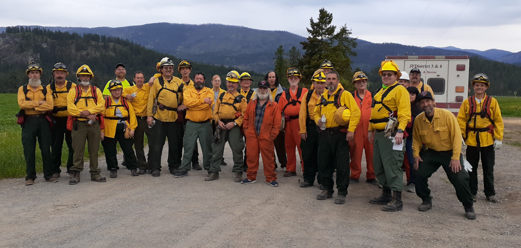
Every year, firefighters have to go through Red Card refresher as part of their wildland training. Part of that is the walk test, one mile carrying 40 pounds of gear on a time limit.
Here were this year’s participants!
Expanded Burn Restrictions, Fire Danger Ratings Increase in Areas of Eastern Washington
Unseasonable dry fuels, warm temps increase fire danger
OLYMPIA – The Washington State Department of Natural Resources (DNR), in cooperation with partner agencies, is adding new burn restrictions on DNR-protected lands in eastern Washington. The new restrictions are a response to increasing fire danger and an increase in fires caused by people burning debris outdoors.
Warming temperatures have dried grasses, and grassy areas are more receptive to even a single spark, which can cause a wildfire. In the Northeast region, 171 wildfires have been started in 2021, including 117 since April 1. Most have been caused by people burning debris outdoors.
The following additional restrictions will be implemented in parts of the Northeast Region, effective Thursday, April 22, 2021:
· Campfires are NOT allowed except in approved designated campgrounds in the following Fire Danger Rating Areas: Foothills, Highlands and Upper Basin in Spokane, and portions of Lincoln County north of Hwy. 2.
· Permit burning (written burn permits issued by DNR) is NOT allowed in the following Fire Danger Rating Areas: Foothills, and Upper Basin in Spokane, and portions of Lincoln County north of Hwy.
· Rule burns are still NOT allowed in the following Fire Danger Rating Areas: Foothills, Highlands and Upper Basin in Spokane, and portions of Lincoln County north of Hwy. 2.
Effective Thursday, April 22, 2021
· Fire Danger will increase from low to moderate in the following Fire Danger Rating Areas: Foothills, Highlands, Lower Basin and Upper Basin.
· Fire Danger will remain low in the following Fire Danger Rating Areas: Chelan, Kaniksu, Lower Yakima, Methow, Upper Yakima and Valley.
Check to find your Fire Danger Rating Area at https://fortress.wa.gov/dnr/protection/firedanger/
These changes are expected to be temporary until “green up” begins, which should start after spring rains allow new grasses to grow.
The best way to be certain a burn pile fully extinguished is to dig into the ash and feel the area with the back of your hand to make sure there is no heat left. It is common for rain to create a cap over the ash, with heat remaining inside. Winds can weaken the cap and allow the pile to reignite. Campfires should be doused with water and stirred until all coals are completely extinguished and is cool to the touch.
A misdemeanor citation will be issued to those who do not comply with a DNR burn restriction. A misdemeanor citation will also be issued for people who do not follow the rules and conditions of their burn permits. If proven negligent, the offender will be billed for the fire suppression costs.
Daily updates on burn restrictions and Industrial Fire Precaution Levels are available at 1-800-323-BURN or on the Fire Danger and Outdoor Burning risk map at https://fortress.wa.gov/dnr/protection/firedanger/ and Industrial Fire Precaution Levels map https://fortress.wa.gov/dnr/protection/ifpl/.
Temporary burn ban in place
There is a temporary Burn Ban in effect for most of Stevens County. All Rule burns are prohibited until further notice.
If there is a question, visit dnr.wa.gov, go to the search window and type in burn restrictions. Click on burn restrictions and a map will show up. In that search window you can type in the address in question and once that pulls up, click anywhere in the area and the current restrictions will show.
Commissioner’s Meeting
The commissioner’s meeting will be Wednesday night @ 6:30pm, (18:30) hours. Masks and social distancing required. Due to the meeting proclamation, the meeting will be closed to the public. The minutes will be on the website at jfpd3-8.org
