Accident Report Card / BVFF
Nine Mine Fire FINAL Update 8.17.21
Orient, WA – The Nine Mine Fire is located 4.5 miles south/southeast of Laurier, WA. This lightning caused fire started on Wednesday, August 4th and has a burned approximately 164 acres of forested land. As of today, the fire is 100% contained.
Evacuations and Road Closures: All evacuation levels have been lifted and there are no road closures.
Yesterday Firefighters scouted the previous night’s rock slide towards the west edge and extinguished unburned fuels found near the fireline. They also patrolled and worked on extinguishing the few hotspots around the remainder of the fireline.
Today In addition to patrolling for hotspots, firefighters will be cleaning up left-over hose, equipment and trash. Roads used by firefighting equipment during the fire will be stabilized. The public may see smoke interior to fireline over the next few days. Northeast Incident Management Team Three will be returning control of the fire to the local North Columbia Washington Department of Natural Resources fire district Tuesday night at 6:00 pm.
Weather for today: Cold front is expected to bring rain showers during the day and possible isolated thunderstorms tonight. Gusty north winds will decrease overnight.
Team Three thanks the community of Orient and the Orient School District for their assistance in the successful management of the Nine Mine Fire.
Facebook at: https://www.facebook.com/newimt3/ and
https://www.facebook.com/newfireinfo/
Inciweb at: https://inciweb.nwcg.gov/incident/7783/
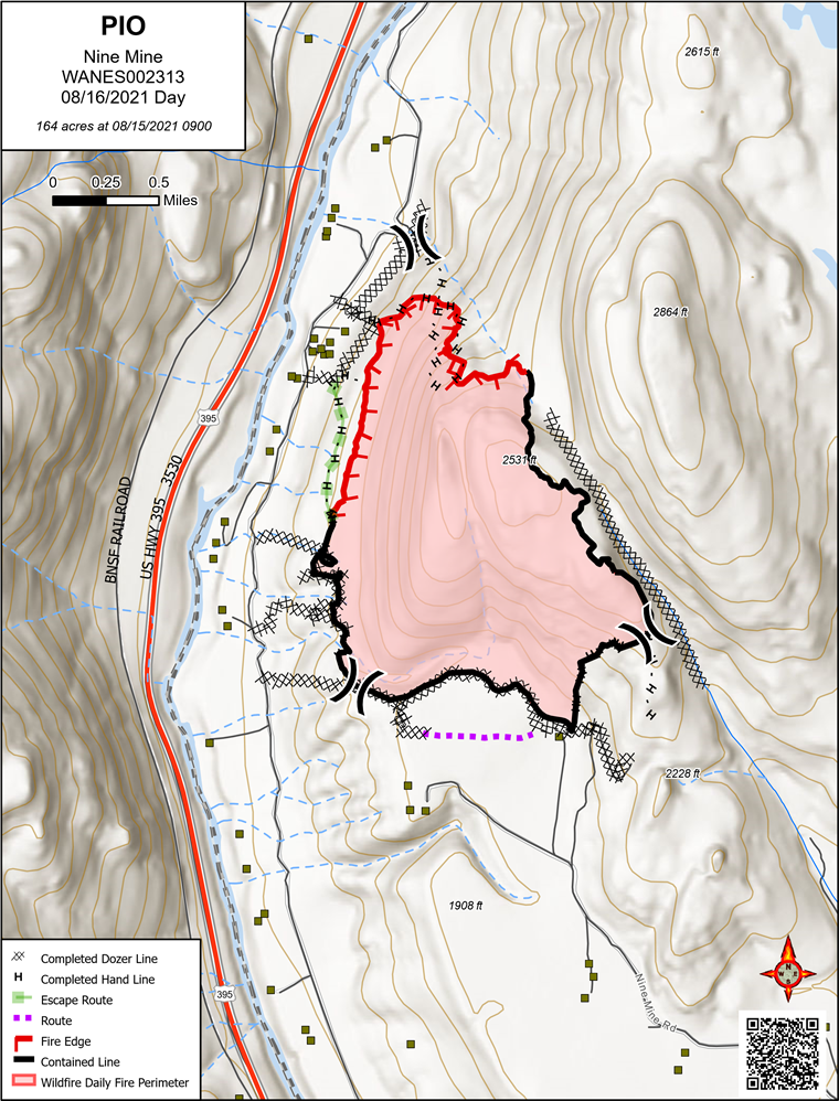
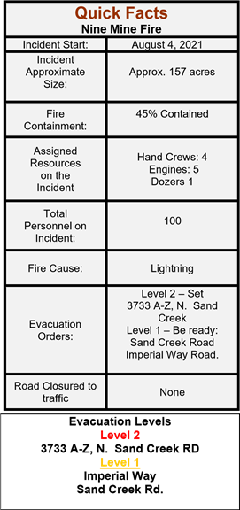
Nine Mine Fire Update and Map 08.16.2021
News Release August 16, 2021
Please Note: Final Nine Mine Fire update will be posted on Tuesday August 17, 2021
Orient, WA – The Nine Mine Fire is located 4.5 miles south/southeast of Laurier, WA. This lightning caused fire started on Wednesday, August 4th and has a burned approximately 164 acres of forested land.
Evacuations: Yesterday evening the Level 2 evacuation for 3733 A-Z, N. Sand Creek Rd was lifted and is now in Level 1 status. The remaining Sand Creek addresses and Imperial Way remain under level 1 evacuation.
Road Closures: No closures
Yesterday During the day, firefighters continued extinguishing hotspots along the northwest, north, and northeast portions of the fire. Firefighters using ground based infrared (IR) detectors found very few hotspots along the eastern perimeter of the fire, so fire managers extended the eastern containment line, increasing total containment to 70%. A dry cold front moved through the area last night, resulting in decreased temperatures and increased relative humidity. A rock slide was reported on the western side of the fire last night.
Today Firefighters will scout the area of last night’s rock slide and extinguish embers that may have rolled into unburned fuels toward the west while taking extra precautions to watch for continued rock slide activity. The east and south edges of the fire are in patrol status, as firefighters watch for and extinguish hot spots near the established fireline. Areas interior to firelines will continue to have hotspots and areas of smoking vegetation. If visibility allows for helicopter flights, firefighters will use water drops to cool areas as needed.
Weather for today: Continued cooling with a chance of rain showers and possible isolated thunderstorms in the afternoon. Light north winds.
Facebook at: https://www.facebook.com/newimt3/ and https://www.facebook.com/newfireinfo/
Inciweb at: https://inciweb.nwcg.gov/incident/7783/
| Quick Facts Nine Mine Fire | |
| Incident Start: | August 4, 2021 |
|
Incident Approximate Size: | Approx. 164 acres |
|
Fire Containment: | 70% Contained |
|
Assigned
Resources on the Incident | Hand Crews: 3 Engines: 4 Dozers 1 |
| Total Personnel on Incident: | 92 |
| Fire Cause: | Lightning |
| Evacuation Orders: | Level 1 – Be ready: N and S Sand Creek Rd. Imperial Way Road |
| Road Closures | None |
Nine Mine Fire – IAP and 209 8-15-21
Bulldog & Mack Mountain Fire Update 8-14-21
Yesterday firefighters were assisted on the ground by the dense smoke over the fire which helped moderate fire activity. This allowed firefighters to make good progress on establishing indirect and contingency containment lines around the entire fire area. Crews utilized heavy equipment to remove fuel from indirect and contingency lines. Falling crews worked to remove dangerous trees and snags so firefighters can work safely in and around the fire. No aircraft were able to fly due to the smoky conditions.
Today crews will continue to finish up indirect containment lines around the fire. Firefighters expect the fire to reach Forest Service Rd 6110 today. This road has been prepared as an indirect fire line and crews will be prepared to suppress the fire as it reaches the road. Helicopters will be used if smoke conditions allow.
The Bulldog Mountain Fire started August 5. 2021, located 20 miles north of Kettle Falls. The lightning caused fire spread quickly due to low relative humidity and unseasonably dry conditions. The fire is burning in heavy timber and slash. The fire is currently estimated at 2900 acres with 5% containment.
Mack Mountain Fire: The Mack Mountain Fire started August 5, 2021 and is just south west of the Bulldog Mountain Fire. The fire is still relatively small but it has grown to approximately 50 acres. Residents in the Deadman Creek area may see smoke from the fire. The fire area is located in steep, rugged terrain with limited access. Fire managers are planning for future action when appropriate and more resources become available.
Citizens should remain vigilant and are strongly encouraged to sign up for alerts at Ferry County Alerts. Motorists traveling on the Boulder Hwy should be vigilant and watch for heavy equipment and firefighters turning off and onto the roadway. There are 185 personnel assigned to the incident. There have been two minor injuries with no structures lost. Firefighter and public safety is our number one priority.
Level 1 evacuation orders and road closures are in place. For current evacuation orders please see Ferry County Sheriff’s Office Facebook page. Boulder Creek Hwy and State Route 395 remain open. For information on area & road closures on the Colville National Forest please see https://www.fs.usda.gov/Internet/FSE_DOCUMENTS/fseprd938379.pdf Citizens are asked to stay clear of the fire area and adhere to road and area closures.
Northeast Washington Interagency Incident Management Team 2 (NEWIMT2) assumed command of the fire August 7th at 11:00 a.m. Fire information and the incident command post is located at Kettle Falls High School in Kettle Falls, WA. Fire information contact is Jeff Sevigney 509 993-2946 or you can also follow us on Facebook at https://www.facebook.com/newimt3/ and Inciweb at https://inciweb.nwcg.gov/incident/7785/
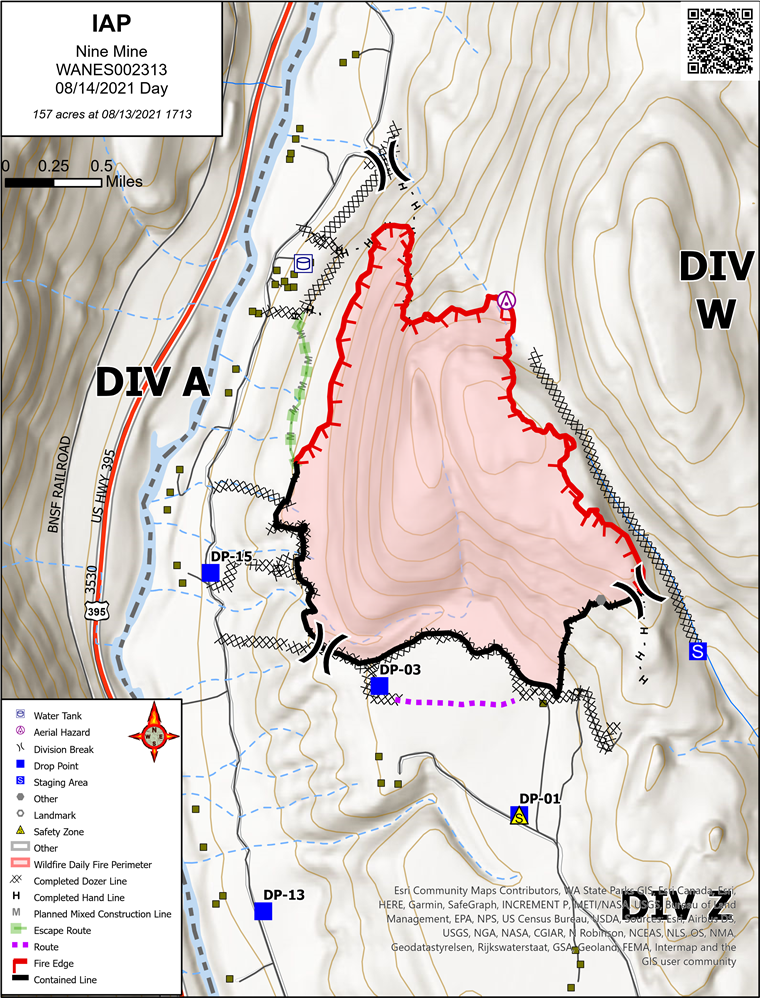
Nine Mine Incident Action Plan and ISS for 8-14-21
Nine Mine Fire update 8-14-21
Orient, WA – The Nine Mine Fire is located 4.5 miles south / southeast from Laurier, WA. This lightning caused fire started on Wednesday, August 4th and has burned approximately 157 acres of forested land. Acreage growth is based on burnout operations.
Evacuations: This morning Level 2 evacuation, for ONLY 3733 A-Z, N. Sand Creek Rd ONLY. This is due to weather, fire behavior and burnout operations.
The remaining Sand Creek addresses and Imperial Way will remain under level 1 evacuation.
Road Closures: Nine Mine Rd. has been reopened to traffic. Use caution if driving this road and watch for fire traffic.
Yesterday, firefighters successfully initiating planned burnout operations along the NW section of division Alpha. Containment lines from division Whiskey to division Alpha were completed and reinforced prior to burnout operations. Zulu division has been moped up 150’ and has been put into a patrol status.
Overnight an IR flight was completed. The aircraft is equipped with the ability to Infrared scan the entire burn area and map fire hot spots within containment lines. This helps fire managers place resources in the areas that need attention.
Today, Firefighter’s mission today will be mop up of the burnout area from yesterday’s operations. Division Z will be in a patrol status while mop up continues in division W.
Sunny skies and hot temperatures with low relative humidity today, along with gusty afternoon winds can change fire behavior and will be monitored throughout the day.
You can also follow up on Facebook at: https://www.facebook.com/newimt3/
https://www.facebook.com/newfireinfo/
And Inciweb at: https://inciweb.nwcg.gov/incident/7783/
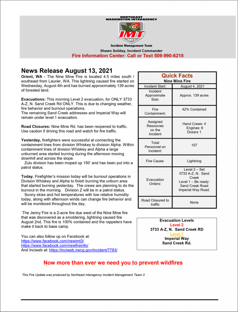
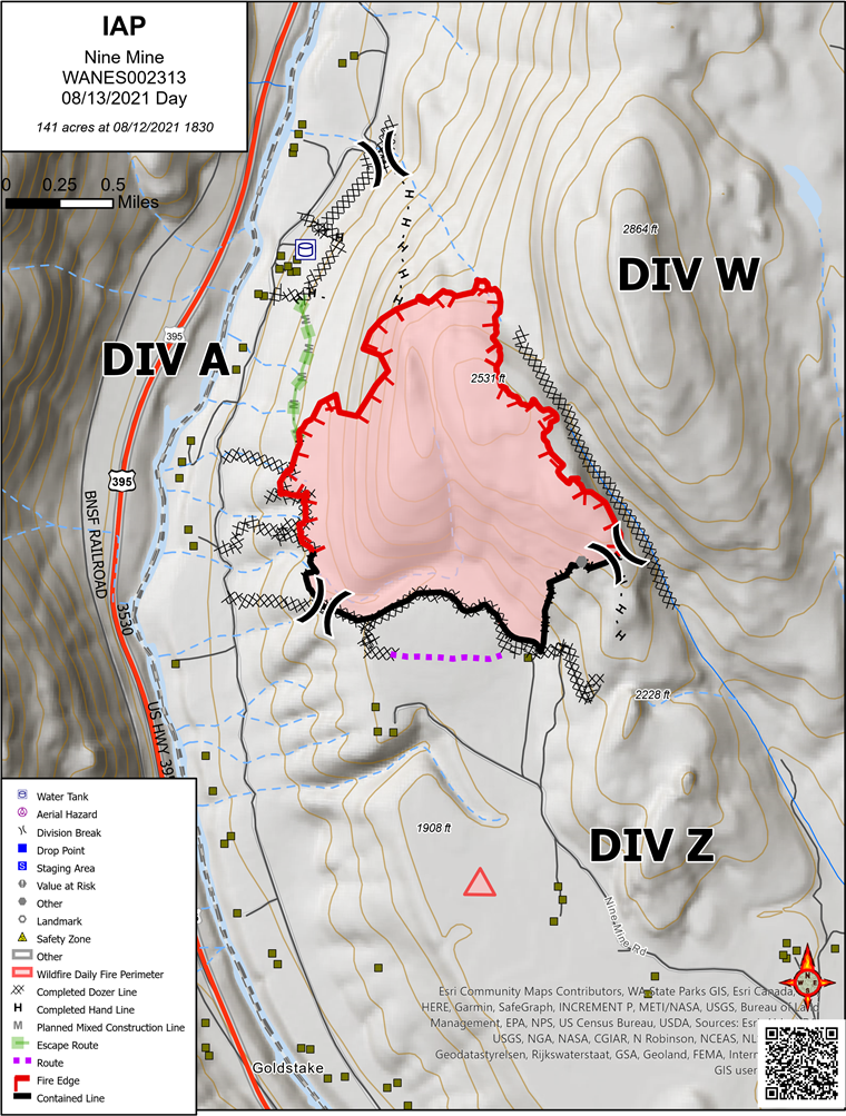
Nine Mine – Fire update 8-13-21
Orient, WA – The Nine Mine Fire is located 4.5 miles south / southeast from Laurier, WA. This lightning caused fire started on Wednesday, August 4th and has burned approximately 139 acres of forested land.
Evacuations: This morning Level 2 evacuation, for ONLY 3733 A-Z, N. Sand Creek Rd ONLY. This is due to changing weather, fire behavior and burnout operations.
The remaining Sand Creek addresses and Imperial Way will remain under level 1 evacuation.
Road Closures: Nine Mine Rd. has been reopened to traffic. Use caution if driving this road and watch for fire traffic.
Yesterday, firefighters were successful at connecting the containment lines from division Whiskey to division Alpha. Within containment lines of division Whiskey and Alpha a large unburned area started burning during the afternoon moving downhill and across the slope.
Zulu division has been moped up 150’ and has been put into a patrol status. Today, Firefighter’s mission today will be burnout operations in Division Whiskey and Alpha to finish burning the unburn area that started burning yesterday. The crews are planning to do the burnout in the morning. Division Z will be in a patrol status.
Sunny skies and hot temperatures with low relative humidity today, along with afternoon winds can change fire behavior and will be monitored throughout the day.
The Jenny Fire is a 2-acre fire due west of the Nine Mine fire that was discovered as a smoldering, lightning caused fire August 2nd. This fire is 100% contained and the rappelers have make it back to base camp.
You can also follow up on Facebook at: https://www.facebook.com/newimt3/
https://www.facebook.com/newfireinfo/
And Inciweb at: https://inciweb.nwcg.gov/incident/7783/
Bulldog & Mack Mountain Fire Update 8-13-21
Bulldog Mountain Fire: Yesterday with help from heavy equipment and firefighters on the ground good progress was made strengthening indirect and contingency lines around the fire. Increased fire activity was observed on all divisions around the fire. Helicopters worked closely with crews on the ground to help cool the fire perimeter.
Today will be another warm day across the region with poor humidity recoveries forecasted. Temperatures will be in the low 90’s on the fire line. Firefighters will continue indirect and contingency line construction today. Direct fire suppression will occur in areas that are safe for crews to engage. Residents around the Bulldog Mtn Fire should remain vigilant and pay close attention to reliable information sources for current fire alerts. Citizens are strongly encouraged to sign up for alerts at Ferry County Alerts. Motorists traveling on the Boulder Hwy should be vigilant and watch for heavy equipment and firefighters turning off and onto the roadway. There are 170 personnel assigned to the incident. There have been no injuries or structures lost. Firefighter and public safety is our number one priority.
The Bulldog Mountain Fire started August 5. 2021, located 20 miles north of Kettle Falls. The lightening caused fire spread quickly due to low relative humidity and unseasonably dry conditions. The fire is burning in heavy timber and slash. Local crews worked hard the first several days conducting direct fire attack as well as identifying areas of the fire that indirect containment line is appropriate due to limited access. Multiple aircraft assisted firefighters on the ground. The fire is currently estimated at 2000 acres with 5% containment.
Mack Mountain Fire: The Mack Mountain Fire started August 5, 2021 and is just south west of the Bulldog Mountain Fire. The fire is still relatively small (approximately 22 acres) and has had minimal activity. Residents in the Deadman Creek area may see smoke from the fire. The fire area is located in steep, rugged terrain with limited to no access. Fire managers are planning for future action when appropriate.
Level 1 evacuation orders and road closures are in place. For current evacuation orders please see Ferry County Sheriff’s Office Facebook page. Boulder Creek Hwy and State Route 395 remain open. For information on area & road closures on the Colville National Forest please see https://www.fs.usda.gov/Internet/FSE_DOCUMENTS/fseprd938379.pdf Citizens are asked to stay clear of the fire area and adhere to road and area closures.
Northeast Washington Interagency Incident Management Team 2 (NEWIMT2) assumed command of the fire August 7th at 11:00 a.m. Fire information and the incident command post is located at Kettle Falls High School in Kettle Falls, WA. Fire information contact is Jeff Sevigney 509 993-2946 or you can also follow us on Facebook at https://www.facebook.com/newimt3/ and Inciweb at https://inciweb.nwcg.gov/incident/7785/

